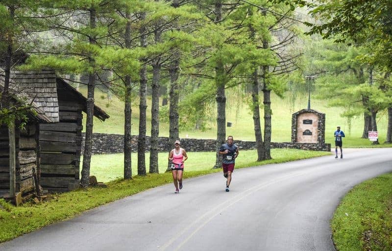
A gorgeously scenic run through the Blue Ridge Mountains that straddle the Tennessee-North Carolina border await runners at the Great Smoky Mountains Half Marathon, which makes its 9th annual running in the late summer along a very gradual climb near the entrance to the national park just outside Knoxville.
Great Smoky Mountains Half Marathon & 5K
September 7, 2024
Townsend
Trail
Distances
Marathon, Half-Marathon, 10k
Starting Time
7:00 AM
Fees
$109 – $149
Perfect For
Ready to sign up?

1,000-10,000

Some Hills

Park Run

High: 83°
/ Low: 64°
Runners should note that this race isn’t actually run inside the confines of Great Smoky Mountains National Park — while the National Park Service allows some running events to be run inside its parks and wildlife areas (like Death Valley), in many cases the environment is too sensitive to allow events like these.
However, you’ll get to experience the feel for what the park is like just outside its gates, as you’ll cross the finish line less than two miles from the park entrance on the Tennessee side, and will get to see the “smoky” mountains that surround Maryville and Townsend all around throughout the race.
The point-to-point course for the race begins just outside Maryville in the small community of Hubbard, where runners will leave the starting line from Heritage High School. From there, they’ll spend much of the next several miles on Old Walland Highway, which will carry them through the small town of Walland on the way to nearby Townsend, where the race will finish.
Along the way, runners can expect a very gradual climb over the race’s 13.1 miles, punctuated with small rolling hills throughout. The climb will probably be barely perceptible for large parts of the race, as you’ll start at an elevation of about 880 feet above sea level and finish at just under 1,100 feet — an elevation gain of only about 130 feet during the race.
The race unfolds mostly along the Old Walland Highway, Cameron Road and Webb Road all the way into Townsend, where the race will finish with a short stretch along the Townsend Historical Trail to the Great Smoky Mountains Association visitor center, just off the Lamar Alexander Parkway.
Spanning more than 816 square miles across Tennessee and North Carolina, Great Smoky Mountains National Park is the nation’s most-visited park for a reason. The Appalachian Trail passes through it, and it features some of the most unspoiled natural beauty anywhere on the U.S. East Coast — havens like Cades Cove and Clingmans Dome, the highest point in the park, are perennial visitor favorites.
Overview
A gorgeously scenic run through the Blue Ridge Mountains that straddle the Tennessee-North Carolina border await runners at the Great Smoky Mountains Half Marathon, which makes its 9th annual running in the late summer along a very gradual climb near the entrance to the national park just outside Knoxville.
Course Description
Runners should note that this race isn’t actually run inside the confines of Great Smoky Mountains National Park — while the National Park Service allows some running events to be run inside its parks and wildlife areas (like Death Valley), in many cases the environment is too sensitive to allow events like these.
However, you’ll get to experience the feel for what the park is like just outside its gates, as you’ll cross the finish line less than two miles from the park entrance on the Tennessee side, and will get to see the “smoky” mountains that surround Maryville and Townsend all around throughout the race.
The point-to-point course for the race begins just outside Maryville in the small community of Hubbard, where runners will leave the starting line from Heritage High School. From there, they’ll spend much of the next several miles on Old Walland Highway, which will carry them through the small town of Walland on the way to nearby Townsend, where the race will finish.
Along the way, runners can expect a very gradual climb over the race’s 13.1 miles, punctuated with small rolling hills throughout. The climb will probably be barely perceptible for large parts of the race, as you’ll start at an elevation of about 880 feet above sea level and finish at just under 1,100 feet — an elevation gain of only about 130 feet during the race.
The race unfolds mostly along the Old Walland Highway, Cameron Road and Webb Road all the way into Townsend, where the race will finish with a short stretch along the Townsend Historical Trail to the Great Smoky Mountains Association visitor center, just off the Lamar Alexander Parkway.
Spanning more than 816 square miles across Tennessee and North Carolina, Great Smoky Mountains National Park is the nation’s most-visited park for a reason. The Appalachian Trail passes through it, and it features some of the most unspoiled natural beauty anywhere on the U.S. East Coast — havens like Cades Cove and Clingmans Dome, the highest point in the park, are perennial visitor favorites.
Past Results
Great Smoky Mountains Half Marathon & 5K Course Map
Distances
Marathon, Half Marathon, 10k
Starting Time
7:00 AM
Fees
$109 – $149

